
Make a donation
Gear up for your next adventure:
As an Amazon Associate, this site earns from qualifying purchases at no extra cost to you.
Jonesborough topographic map
Click on the map to display elevation.
Make a donation
Gear up for your next adventure:
As an Amazon Associate, this site earns from qualifying purchases at no extra cost to you.
About this map
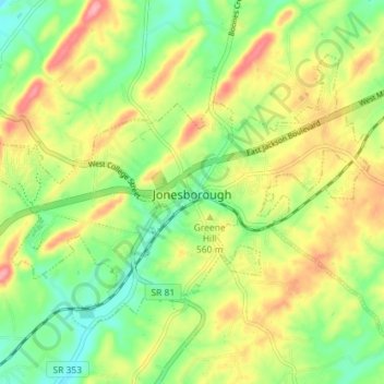
Name: Jonesborough topographic map, elevation, terrain.
Average elevation: 1,781 ft
Minimum elevation: 1,631 ft
Maximum elevation: 1,972 ft
Washington County trails, hiking, mountain biking, running and outdoor activities
Make a donation
Gear up for your next adventure:
As an Amazon Associate, this site earns from qualifying purchases at no extra cost to you.
Other topographic maps
Click on a map to view its topography, its elevation and its terrain.
Make a donation
Gear up for your next adventure:
As an Amazon Associate, this site earns from qualifying purchases at no extra cost to you.
Make a donation
Gear up for your next adventure:
As an Amazon Associate, this site earns from qualifying purchases at no extra cost to you.
Greenfield Heights
United States > Tennessee > Washington County > Johnson City
Average elevation: 1,637 ft
Montcastle Hills
United States > Tennessee > Washington County > Johnson City
Average elevation: 1,660 ft
Make a donation
Gear up for your next adventure:
As an Amazon Associate, this site earns from qualifying purchases at no extra cost to you.
Dogwood Acres
United States > Tennessee > Washington County > Johnson City
Average elevation: 1,804 ft
East Ridge
United States > Tennessee > Washington County > Johnson City > East Ridge
Average elevation: 1,670 ft
Make a donation
Gear up for your next adventure:
As an Amazon Associate, this site earns from qualifying purchases at no extra cost to you.
Carnegie
United States > Tennessee > Washington County > Johnson City > Carnegie
Average elevation: 1,657 ft