Geolocate

Honda topographic map

Click on the map to display elevation.

About this map

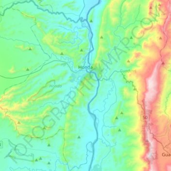
Name: Honda topographic map, elevation, terrain.

Location: Honda, Norte, Tolima, 732040, Colombia (5.03983 -74.88644 5.31946 -74.71441)

Average elevation: 1,545 ft

Minimum elevation: 587 ft

Maximum elevation: 4,892 ft

Other topographic maps

Click on a map to view its topography, its elevation and its terrain.

Parque Mitológico

Colombia > Tolima > Espinal

Average elevation: 1,066 ft

Toche

Colombia > Tolima

Average elevation: 7,733 ft

Alto De Letras

Colombia > Tolima

Average elevation: 4,957 ft

Gaitan

Colombia > Tolima > Gaitan

Average elevation: 3,930 ft

Piedras

Colombia > Tolima > Piedras

Average elevation: 1,362 ft

Gear up for your next adventure:

Backpacking Tent - Lightweight and durable tent for multi‑day hikes
🧦Hiking Socks - Comfortable socks to prevent blisters on long hikes
🔭Compact Binoculars - HD vision for scouting terrain and identifying distant landmarks
🪑Portable Camp Table - Compact table for campsite meals
🩳Quick‑Dry Hiking Shorts - Comfortable and quick‑dry shorts for summer hiking

As an Amazon Associate, this site earns from qualifying purchases at no extra cost to you.