
Make a donation
Gear up for your next adventure:
As an Amazon Associate, this site earns from qualifying purchases at no extra cost to you.
Khan Daun Penh topographic map
Click on the map to display elevation.
Make a donation
Gear up for your next adventure:
As an Amazon Associate, this site earns from qualifying purchases at no extra cost to you.
About this map
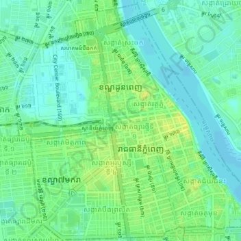
Name: Khan Daun Penh topographic map, elevation, terrain.
Location: Khan Daun Penh, Phnom Penh, Cambodia (11.55563 104.90392 11.58957 104.93960)
Average elevation: 43 ft
Minimum elevation: 16 ft
Maximum elevation: 79 ft
Make a donation
Gear up for your next adventure:
As an Amazon Associate, this site earns from qualifying purchases at no extra cost to you.
Other topographic maps
Click on a map to view its topography, its elevation and its terrain.
Make a donation
Gear up for your next adventure:
As an Amazon Associate, this site earns from qualifying purchases at no extra cost to you.
Make a donation
Gear up for your next adventure:
As an Amazon Associate, this site earns from qualifying purchases at no extra cost to you.
Phum Prey Lvea
Cambodia > Phnom Penh > Khan Pou Senchey > Sangkat Chaom Chau 2
Average elevation: 43 ft
Make a donation
Gear up for your next adventure:
As an Amazon Associate, this site earns from qualifying purchases at no extra cost to you.
Phum Trapeang Svay
Cambodia > Phnom Penh > Khan Sen Sok > Sangkat Kouk Khleang
Average elevation: 36 ft
Make a donation
Gear up for your next adventure:
As an Amazon Associate, this site earns from qualifying purchases at no extra cost to you.
Phum Bourei Muoy Roy Khnorng
Cambodia > Phnom Penh > Khan Sen Sok > Sangkat Teuk Thla
Average elevation: 39 ft
Make a donation
Gear up for your next adventure:
As an Amazon Associate, this site earns from qualifying purchases at no extra cost to you.
Make a donation
Gear up for your next adventure:
As an Amazon Associate, this site earns from qualifying purchases at no extra cost to you.
Phum Tuol Thngan
Cambodia > Phnom Penh > Khan Russey Keo > Sangkat Tuol Sangkae 2
Average elevation: 33 ft
Make a donation
Gear up for your next adventure:
As an Amazon Associate, this site earns from qualifying purchases at no extra cost to you.
Phum Trapeang Chhuk
Cambodia > Phnom Penh > Khan Sen Sok > Sangkat Ou Baek K'am
Average elevation: 39 ft
Make a donation
Gear up for your next adventure:
As an Amazon Associate, this site earns from qualifying purchases at no extra cost to you.
Sangkat Phsar Kandal Ti Pir
Cambodia > Phnom Penh > Khan Daun Penh > Sangkat Phsar Kandal Ti Pir
Average elevation: 39 ft
Make a donation
Gear up for your next adventure:
As an Amazon Associate, this site earns from qualifying purchases at no extra cost to you.
Sangkat Phsar Kandal Ti Muoy
Cambodia > Phnom Penh > Khan Daun Penh > Sangkat Phsar Kandal Ti Muoy
Average elevation: 39 ft
Phum Tuol Sambour
Cambodia > Phnom Penh > Khan Dangkao > Sangkat Prey Veng > Phum Tuol Sambour
Average elevation: 39 ft