
Make a donation
Gear up for your next adventure:
As an Amazon Associate, this site earns from qualifying purchases at no extra cost to you.
Erpe topographic map
Click on the map to display elevation.
Make a donation
Gear up for your next adventure:
As an Amazon Associate, this site earns from qualifying purchases at no extra cost to you.
Erpe
Sommige Erpenaren hadden vroeger twee bijnamen. De bekendste was De Palokeneters. Minder bekend was De Dieven. Het hoogste punt van de deelgemeente Erpe bevindt zich aan de kruising van de E40 met de Merestraat, de top ligt op een hoogte van 44 meter boven zeeniveau.
Make a donation
Gear up for your next adventure:
As an Amazon Associate, this site earns from qualifying purchases at no extra cost to you.
About this map
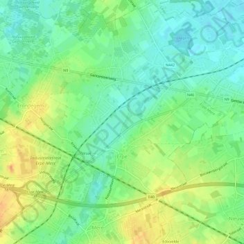
Name: Erpe topographic map, elevation, terrain.
Location: Erpe, Erpe-Mere, Aalst, Oost-Vlaanderen, België (50.92066 3.95680 50.95598 4.01124)
Average elevation: 85 ft
Minimum elevation: 30 ft
Maximum elevation: 164 ft
Make a donation
Gear up for your next adventure:
As an Amazon Associate, this site earns from qualifying purchases at no extra cost to you.
Other topographic maps
Click on a map to view its topography, its elevation and its terrain.
Denderarm Sluis Geeraardsbergen
België > Oost-Vlaanderen > Aalst > Geraardsbergen
Average elevation: 125 ft
Make a donation
Gear up for your next adventure:
As an Amazon Associate, this site earns from qualifying purchases at no extra cost to you.
Make a donation
Gear up for your next adventure:
As an Amazon Associate, this site earns from qualifying purchases at no extra cost to you.
Make a donation
Gear up for your next adventure:
As an Amazon Associate, this site earns from qualifying purchases at no extra cost to you.
Provinciaal Domein "De Gavers"
België > Oost-Vlaanderen > Aalst > Geraardsbergen
Average elevation: 75 ft
Erpe-Mere
België > Oost-Vlaanderen > Aalst > Mere
Erpe-Mere ligt op uitlopers van de heuvelzone van de Vlaamse Ardennen en in de Denderstreek. Het gebied ten noorden van de weg Aalst-Gent (N9) ligt op 10 tot 30 meter hoogte, het gebied tussen de N9 en de E40 Brussel-Gent ligt op een hoogte tussen 25 en 50 meter en het gebied ten zuiden daarvan heeft…
Average elevation: 125 ft
Hemelrijk
België > Oost-Vlaanderen > Aalst > Denderleeuw > Hemelrijk
Denderleeuw en het gehucht Leeuwbrug ontwikkelden zich in een hoefijzervorm langs de Dender, die ter hoogte van Denderleeuw van richting verandert. Het gebied van Hemelrijk bleef lang een landelijk gebied op het plateau ten westen van de Dender.
Average elevation: 66 ft
Make a donation
Gear up for your next adventure:
As an Amazon Associate, this site earns from qualifying purchases at no extra cost to you.
Strijmeers
België > Oost-Vlaanderen > Aalst > Sint-Lievens-Houtem > Vlierzele
Average elevation: 112 ft
Make a donation
Gear up for your next adventure:
As an Amazon Associate, this site earns from qualifying purchases at no extra cost to you.