
Make a donation
Gear up for your next adventure:
As an Amazon Associate, this site earns from qualifying purchases at no extra cost to you.
El Cerrillo Piedras Blancas topographic map
Click on the map to display elevation.
Make a donation
Gear up for your next adventure:
As an Amazon Associate, this site earns from qualifying purchases at no extra cost to you.
About this map
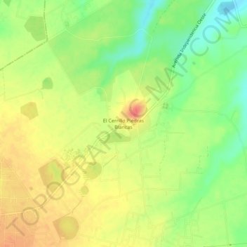
Name: El Cerrillo Piedras Blancas topographic map, elevation, terrain.
Average elevation: 8,517 ft
Minimum elevation: 8,425 ft
Maximum elevation: 8,593 ft
Make a donation
Gear up for your next adventure:
As an Amazon Associate, this site earns from qualifying purchases at no extra cost to you.
Other topographic maps
Click on a map to view its topography, its elevation and its terrain.
Río Verdiguel
México > Estado de México > Toluca > San Andres Coexcotitlan
Average elevation: 8,550 ft
Make a donation
Gear up for your next adventure:
As an Amazon Associate, this site earns from qualifying purchases at no extra cost to you.
Área de Protección de Flora y Fauna Nevado de Toluca
México > Estado de México > Toluca
Average elevation: 10,121 ft
Make a donation
Gear up for your next adventure:
As an Amazon Associate, this site earns from qualifying purchases at no extra cost to you.