
Make a donation
Gear up for your next adventure:
As an Amazon Associate, this site earns from qualifying purchases at no extra cost to you.
Dandong City topographic map
Click on the map to display elevation.
Make a donation
Gear up for your next adventure:
As an Amazon Associate, this site earns from qualifying purchases at no extra cost to you.
About this map
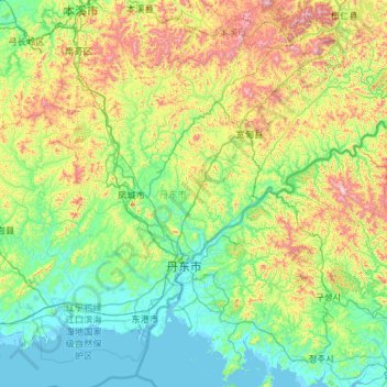
Name: Dandong City topographic map, elevation, terrain.
Location: Dandong City, Liaoning, China (39.74615 123.37104 41.15281 125.70199)
Average elevation: 843 ft
Minimum elevation: -7 ft
Maximum elevation: 4,570 ft
Make a donation
Gear up for your next adventure:
As an Amazon Associate, this site earns from qualifying purchases at no extra cost to you.
Other topographic maps
Click on a map to view its topography, its elevation and its terrain.
Make a donation
Gear up for your next adventure:
As an Amazon Associate, this site earns from qualifying purchases at no extra cost to you.
Make a donation
Gear up for your next adventure:
As an Amazon Associate, this site earns from qualifying purchases at no extra cost to you.
Make a donation
Gear up for your next adventure:
As an Amazon Associate, this site earns from qualifying purchases at no extra cost to you.
Make a donation
Gear up for your next adventure:
As an Amazon Associate, this site earns from qualifying purchases at no extra cost to you.
Make a donation
Gear up for your next adventure:
As an Amazon Associate, this site earns from qualifying purchases at no extra cost to you.
Anshan
China > Liaoning > Shengli Subdistrict
Local transportation is primarily by bus or taxi. Anshan used to have a single tram line—along Zhonghua Avenue, through the city centre and past Angang main gate—but this has been closed and the tracks removed. Due to the flat topography of the city centre, bicycles are popular. Almost all roads have a…
Average elevation: 259 ft
Anshan
China > Liaoning > Anshan > Shengli Subdistrict
Local transportation is primarily by bus or taxi. Anshan used to have a single tram line—along Zhonghua Avenue, through the city centre and past Angang main gate—but this has been closed and the tracks removed. Due to the flat topography of the city centre, bicycles are popular. Almost all roads have a…
Average elevation: 259 ft
Make a donation
Gear up for your next adventure:
As an Amazon Associate, this site earns from qualifying purchases at no extra cost to you.
Hongqiyingzi
China > Liaoning > Xiuyan Manchu Autonomous County > Hongqiyingzi
Average elevation: 554 ft