
Make a donation
Gear up for your next adventure:
As an Amazon Associate, this site earns from qualifying purchases at no extra cost to you.
Zona 6 topographic map
Click on the map to display elevation.
Make a donation
Gear up for your next adventure:
As an Amazon Associate, this site earns from qualifying purchases at no extra cost to you.
About this map
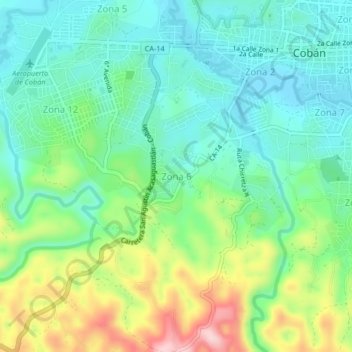
Name: Zona 6 topographic map, elevation, terrain.
Location: Zona 6, Cobán, Zona 12, Alta Verapaz, 16001, Guatemala (15.43614 -90.40920 15.47614 -90.36920)
Average elevation: 4,505 ft
Minimum elevation: 4,249 ft
Maximum elevation: 5,089 ft
Make a donation
Gear up for your next adventure:
As an Amazon Associate, this site earns from qualifying purchases at no extra cost to you.
Other topographic maps
Click on a map to view its topography, its elevation and its terrain.
Parque Natural Monumento a la Paz de Guatemala
Guatemala > Alta Verapaz > Cobán > Zona 11
Average elevation: 4,354 ft
Make a donation
Gear up for your next adventure:
As an Amazon Associate, this site earns from qualifying purchases at no extra cost to you.