Geolocate

Oak Ridge topographic map

Click on the map to display elevation.

About this map

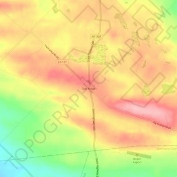
Name: Oak Ridge topographic map, elevation, terrain.

Location: Oak Ridge, Town of Charleston, Montgomery County, New York, 12160, United States (42.77646 -74.36013 42.81646 -74.32013)

Average elevation: 1,257 ft

Minimum elevation: 988 ft

Maximum elevation: 1,440 ft

Montgomery County trails, hiking, mountain biking, running and outdoor activities

Other topographic maps

Click on a map to view its topography, its elevation and its terrain.

Town of Glen

United States > New York > Montgomery County

Average elevation: 597 ft

Town of Glen

United States > New York > Montgomery County

Average elevation: 597 ft

Gear up for your next adventure:

🦶Carbon Trekking Poles - Reduce knee impact on steep descents with ultra-light poles
🛌Ultralight Sleeping Bags - Compact down bags for cold nights in the wilderness
🗺️NatGeo Topo Maps - High-quality waterproof printed topographic maps of US Parks
🗃️Trail First Aid Kit - Essential kit for outdoor injuries and emergencies
🎒Trekking Poles - Sturdy poles for balance and stability on rough terrain

As an Amazon Associate, this site earns from qualifying purchases at no extra cost to you.