Geolocate

Cameron topographic map

Click on the map to display elevation.

About this map

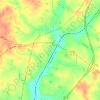
Name: Cameron topographic map, elevation, terrain.

Location: Cameron, Moore County, North Carolina, United States (35.31443 -79.27990 35.33341 -79.23202)

Average elevation: 358 ft

Minimum elevation: 269 ft

Maximum elevation: 427 ft

Moore County trails, hiking, mountain biking, running and outdoor activities

Other topographic maps

Click on a map to view its topography, its elevation and its terrain.

Spies

United States > North Carolina > Moore County

Average elevation: 482 ft

Lobelia

United States > North Carolina > Moore County

Average elevation: 236 ft

Sandhill

United States > North Carolina > Moore County > Foxfire

Average elevation: 456 ft

Gear up for your next adventure:

🚪Portable Camp Chair - Foldable chair for comfort at camp
🩹Survival Bandages - High‑quality bandages for emergencies
🛠️Outdoor Gear Repair Kit - Essential tools to fix gear on the trail
🎒Gear Packing Cubes - Organize your backpack efficiently
📦Dry Bags Set - Waterproof storage for electronics and clothes

As an Amazon Associate, this site earns from qualifying purchases at no extra cost to you.