
Thank you for supporting this site ❤️
Make a donation
Make a donation
Gear up for your next adventure:
As an Amazon Associate, this site earns from qualifying purchases at no extra cost to you.
Tamarit topographic map
Click on the map to display elevation.
Thank you for supporting this site ❤️
Make a donation
Make a donation
Gear up for your next adventure:
As an Amazon Associate, this site earns from qualifying purchases at no extra cost to you.
About this map
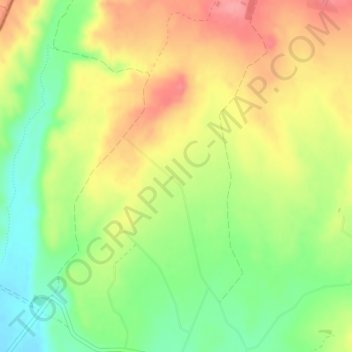
Name: Tamarit topographic map, elevation, terrain.
Location: Tamarit, Tauste, Cinco Villas, Zaragoza, Aragón, Spanje (41.95269 -1.36153 41.97269 -1.34153)
Average elevation: 974 ft
Minimum elevation: 830 ft
Maximum elevation: 1,115 ft
Thank you for supporting this site ❤️
Make a donation
Make a donation
Gear up for your next adventure:
As an Amazon Associate, this site earns from qualifying purchases at no extra cost to you.