
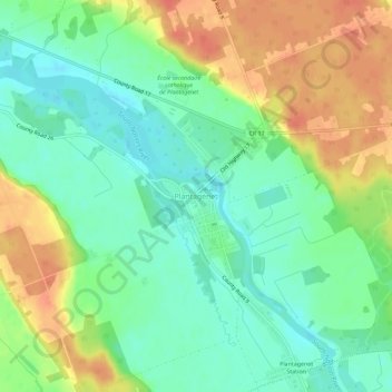
Plantagenet topographic map
Interactive map
Click on the map to display elevation.
About this map
Name: Plantagenet topographic map, elevation, terrain.
Average elevation: 200 ft
Minimum elevation: 131 ft
Maximum elevation: 295 ft
Other topographic maps
Click on a map to view its topography, its elevation and its terrain.
Lefaivre
Canada > Ontario > Prescott and Russell Counties > Alfred and Plantagenet
Lefaivre, Alfred and Plantagenet, Prescott and Russell Counties, Eastern Ontario, Ontario, K0B 1J0, Canada
Average elevation: 164 ft
Wendover
Canada > Ontario > Prescott and Russell Counties > Alfred and Plantagenet > Wendover
Wendover, Alfred and Plantagenet, Prescott and Russell Counties, Eastern Ontario, Ontario, K0A 3K0, Canada
Average elevation: 161 ft
Alfred
Canada > Ontario > Prescott and Russell Counties > Alfred and Plantagenet
Alfred, Alfred and Plantagenet, Prescott and Russell Counties, Eastern Ontario, Ontario, K0B 1A0, Canada
Average elevation: 210 ft