Geolocate

Celico topographic map

Click on the map to display elevation.

About this map

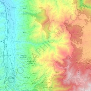
Name: Celico topographic map, elevation, terrain.

Location: Celico, Cosenza, Calabria, Italy (39.29268 16.30902 39.45321 16.53895)

Average elevation: 2,635 ft

Minimum elevation: 308 ft

Maximum elevation: 6,253 ft

Other topographic maps

Click on a map to view its topography, its elevation and its terrain.

Savuto

Italy > Calabria > Cosenza > Cleto

Average elevation: 932 ft

Lago dell'Esaro

Italy > Calabria > Cosenza > Roggiano Gravina

Average elevation: 512 ft

Gear up for your next adventure:

🎒Gear Packing Cubes - Organize your backpack efficiently
🧢Sun Protection Hats - Wide-brimmed and UPF-rated hats for high-altitude sun safety
🥘Titanium Cookware - Durable, featherlight pots and pans for backpacking
🪶Compact Camp Shovel - Folding shovel for campsite tasks
🏥Hiking First Aid Kits - Comprehensive medical kits for remote trail injuries

As an Amazon Associate, this site earns from qualifying purchases at no extra cost to you.