Geolocate

Melvindale topographic map

Click on the map to display elevation.

About this map

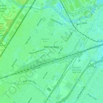
Name: Melvindale topographic map, elevation, terrain.

Location: Melvindale, Wayne County, Michigan, 48122, United States (42.26458 -83.20126 42.29748 -83.15801)

Average elevation: 594 ft

Minimum elevation: 574 ft

Maximum elevation: 610 ft

Other topographic maps

Click on a map to view its topography, its elevation and its terrain.

Perrinville

United States > Michigan > Wayne County > Westland

Average elevation: 640 ft

Sunnyside

United States > Michigan > Wayne County > Romulus

Average elevation: 636 ft

Calvert Park

United States > Michigan > Wayne County > Detroit

Average elevation: 643 ft

Elm

United States > Michigan > Wayne County > Livonia

Average elevation: 640 ft

Newburg

United States > Michigan > Wayne County > Livonia

Average elevation: 686 ft

Dearborn

United States > Michigan > Wayne County > Dearborn

Average elevation: 623 ft

Gear up for your next adventure:

🧭Compass with Lanyard - Easy‑carry compass for navigation
🗻Climbing Gear Basics - Essential gear for beginner climbers
👓Polarized Sunglasses - Outdoor sunglasses for glare reduction
🥾Men's Hiking Boots - Durable, waterproof footwear for rugged terrain and steep inclines
📷Action Camera - Capture your outdoor adventures in HD

As an Amazon Associate, this site earns from qualifying purchases at no extra cost to you.