
Make a donation
Gear up for your next adventure:
As an Amazon Associate, this site earns from qualifying purchases at no extra cost to you.
Nürburg topographic map
Click on the map to display elevation.
Make a donation
Gear up for your next adventure:
As an Amazon Associate, this site earns from qualifying purchases at no extra cost to you.
Nürburg
Nürburg has a semi-continental climate with both oceanic and continental tendencies. It does however land in the former category (Köppen Cfb). With regards to the racetrack, due to the Nordschleife's varied terrain and elevation, weather may be completely different on either end of the track. The elevation shift also makes thermal differences a strong possibility. The modern Grand Prix circuit also has sizeable elevation changes between the start-finish straight and the lowest point on the opposite end of the track, but the geographical distance and actual elevation gain between the two are lower. Annual sunshine is in the 1500s, which is low by European standards, but sunnier than the nearest large city of Cologne. Contrasting that, Nürburg has cooler weather year-round due to the higher elevation of the Eifel Mountains than the Rhine Valley.
Make a donation
Gear up for your next adventure:
As an Amazon Associate, this site earns from qualifying purchases at no extra cost to you.
About this map
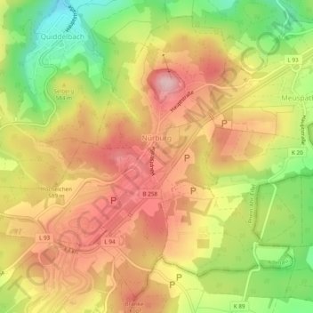
Name: Nürburg topographic map, elevation, terrain.
Average elevation: 1,837 ft
Minimum elevation: 1,444 ft
Maximum elevation: 2,142 ft
Make a donation
Gear up for your next adventure:
As an Amazon Associate, this site earns from qualifying purchases at no extra cost to you.