Geolocate

Tres Piedras topographic map

Click on the map to display elevation.

About this map

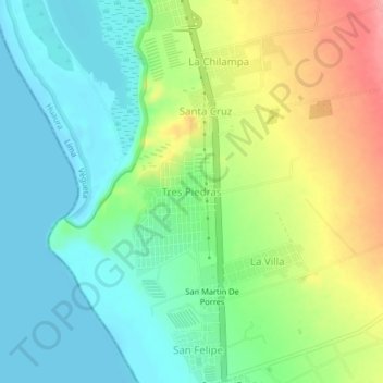
Name: Tres Piedras topographic map, elevation, terrain.

Location: Tres Piedras, Végueta, Province of Huaura, Lima, Peru (-10.97329 -77.66943 -10.93329 -77.62943)

Average elevation: 115 ft

Minimum elevation: 0 ft

Maximum elevation: 325 ft

Gear up for your next adventure:

📌Outdoor GPS Map App - Apps and devices for digital topographic navigation
Solar GPS Watches - Advanced multisport watches with built-in topographic maps
💧Water Purification System - Clean water on the trail with reliable purifiers
🔊Portable Camp Speaker - Music and alerts at camp
🩹Survival Bandages - High‑quality bandages for emergencies

As an Amazon Associate, this site earns from qualifying purchases at no extra cost to you.