
Thank you for supporting this site ❤️
Make a donation
Make a donation
Gear up for your next adventure:
As an Amazon Associate, this site earns from qualifying purchases at no extra cost to you.
Janjheli topographic map
Click on the map to display elevation.
Thank you for supporting this site ❤️
Make a donation
Make a donation
Gear up for your next adventure:
As an Amazon Associate, this site earns from qualifying purchases at no extra cost to you.
About this map
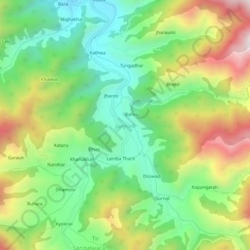
Name: Janjheli topographic map, elevation, terrain.
Location: Janjheli, Thunag, Mandi, Himachal Pradesh, 175047, India (31.49678 77.20141 31.53678 77.24141)
Average elevation: 7,487 ft
Minimum elevation: 6,430 ft
Maximum elevation: 9,144 ft
Thank you for supporting this site ❤️
Make a donation
Make a donation
Gear up for your next adventure:
As an Amazon Associate, this site earns from qualifying purchases at no extra cost to you.