
Make a donation
Gear up for your next adventure:
As an Amazon Associate, this site earns from qualifying purchases at no extra cost to you.
Océan Atlantique topographic map
Click on the map to display elevation.
Make a donation
Gear up for your next adventure:
As an Amazon Associate, this site earns from qualifying purchases at no extra cost to you.
About this map
Name: Océan Atlantique topographic map, elevation, terrain.
Average elevation: 535 ft
Minimum elevation: 328 ft
Maximum elevation: 719 ft
Make a donation
Gear up for your next adventure:
As an Amazon Associate, this site earns from qualifying purchases at no extra cost to you.
Other topographic maps
Click on a map to view its topography, its elevation and its terrain.
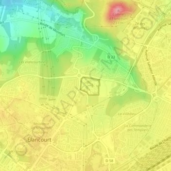
Colline d'Élancourt
France > Île-de-France > Yvelines > Élancourt
La colline d'Élancourt, ou colline de la Revanche, est une colline située à Élancourt dans le département français des Yvelines. S'élevant à 231 mètres d'altitude, elle est le point culminant de toute la région Île-de-France.
Average elevation: 535 ft