
Garnet topographic map
Click on the map to display elevation.
Garnet
In First Chance Gulch in western Montana, the town is located 11 miles up the Garnet Range Road, in mountains and forest. The town is at approximately 6,000 feet (1,800 m) elevation. The nearest city is Missoula, approximately 20 miles (32 km) to the west. The closest city to the east is Butte, about 100 miles (160 km) away.
About this map
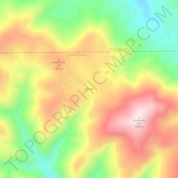
Name: Garnet topographic map, elevation, terrain.
Location: Garnet, Granite County, Montana, United States (46.80521 -113.35896 46.84521 -113.31896)
Average elevation: 5,768 ft
Minimum elevation: 4,724 ft
Maximum elevation: 6,798 ft
Granite County trails, hiking, mountain biking, running and outdoor activities
Other topographic maps
Click on a map to view its topography, its elevation and its terrain.