
Make a donation
Gear up for your next adventure:
As an Amazon Associate, this site earns from qualifying purchases at no extra cost to you.
Pizzo Rotondo topographic map
Click on the map to display elevation.
Make a donation
Gear up for your next adventure:
As an Amazon Associate, this site earns from qualifying purchases at no extra cost to you.
About this map
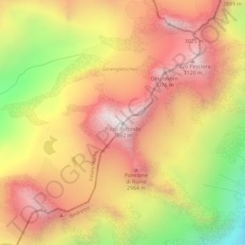
Name: Pizzo Rotondo topographic map, elevation, terrain.
Location: Pizzo Rotondo, Obergoms, Goms, Wallis, 6781, Schweiz (46.51765 8.46613 46.51775 8.46623)
Average elevation: 8,793 ft
Minimum elevation: 6,631 ft
Maximum elevation: 10,305 ft
Make a donation
Gear up for your next adventure:
As an Amazon Associate, this site earns from qualifying purchases at no extra cost to you.
Other topographic maps
Click on a map to view its topography, its elevation and its terrain.
Rhonegletscher
Schweiz > Wallis > Goms > Obergoms
Der Rhonegletscher entsteht am verhältnismässig flachen Südwesthang des Winterbergmassivs am Dammastock auf rund 3600 m ü. M. Auf den ersten 2,5 km trägt das Eisfeld den Namen Eggfirn und überwindet eine Höhendifferenz von etwa 600 m. Auf 3080 m ist der Gletscher durch die firnbedeckte Untere…
Average elevation: 9,203 ft