Geolocate

Raithal topographic map

Click on the map to display elevation.

About this map

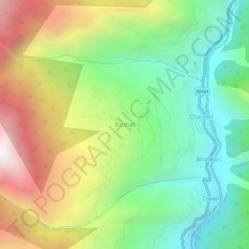
Name: Raithal topographic map, elevation, terrain.

Location: Raithal, Bhatwari, Uttarkashi district, Uttarakhand, India (30.79672 78.58379 30.83672 78.62379)

Average elevation: 6,962 ft

Minimum elevation: 4,911 ft

Maximum elevation: 10,092 ft

Other topographic maps

Click on a map to view its topography, its elevation and its terrain.

Kyarkoti Lake

India > Uttarakhand > Bhatwari

Average elevation: 13,264 ft

Harsil

India > Uttarakhand > Bhatwari

Average elevation: 9,058 ft

Pari Maatri Taal

India > Uttarakhand > Bhatwari

Average elevation: 14,577 ft

Kedar Tal

India > Uttarakhand > Bhatwari

Average elevation: 15,794 ft

Dayara Bugyal

India > Uttarakhand > Bhatwari

Average elevation: 11,322 ft

Harsil

India > Uttarakhand > Bhatwari

Average elevation: 9,058 ft

Kalindi Khal Area

India > Uttarakhand > Bhatwari

Average elevation: 19,216 ft

Gangotri Glacier

India > Uttarakhand > Bhatwari

Average elevation: 17,254 ft

Kedar Tal

India > Uttarakhand > Bhatwari

Average elevation: 15,794 ft

Gangotri Glacier

India > Uttarakhand > Bhatwari

Average elevation: 17,254 ft

Gear up for your next adventure:

🌲Outdoor Survival Books - Best books on survival skills
🔦LED Headlamp - Bright and durable LED headlamp for night navigation
📌Outdoor GPS Map App - Apps and devices for digital topographic navigation
🌡️Portable Weather Meter - Track weather conditions on the trail
🎒Outdoor Daypacks - Lightweight backpacks designed for carrying maps and essential gear

As an Amazon Associate, this site earns from qualifying purchases at no extra cost to you.