Geolocate

Zoverallo topographic map

Click on the map to display elevation.

About this map

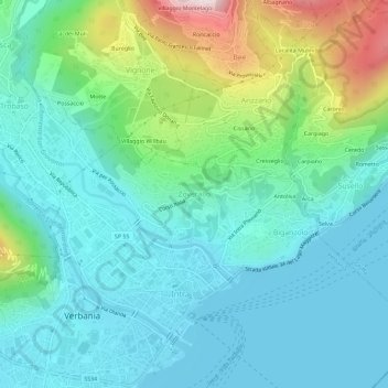
Name: Zoverallo topographic map, elevation, terrain.

Location: Zoverallo, Verbania, Verbano-Cusio-Ossola, Piedmont, 28921, Italy (45.92696 8.55464 45.96696 8.59464)

Average elevation: 1,056 ft

Minimum elevation: 620 ft

Maximum elevation: 2,516 ft

Other topographic maps

Click on a map to view its topography, its elevation and its terrain.

Gear up for your next adventure:

🛰️Satellite Messengers - Emergency SOS and two-way messaging for off-grid adventures
🔭Stargazing Telescopes - Perfect for camping in low-light pollution areas shown on maps
🔥Plasma Lighters - Windproof lighters that work in any weather condition
📚Navigation Handbooks - Master the art of reading topographic maps and using a compass
🎒Day Hiking Backpack - Lightweight backpack perfect for day trips and outdoor adventures

As an Amazon Associate, this site earns from qualifying purchases at no extra cost to you.