
Thank you for supporting this site ❤️
Make a donation
Make a donation
Gear up for your next adventure:
As an Amazon Associate, this site earns from qualifying purchases at no extra cost to you.
Gasenried topographic map
Click on the map to display elevation.
Thank you for supporting this site ❤️
Make a donation
Make a donation
Gear up for your next adventure:
As an Amazon Associate, this site earns from qualifying purchases at no extra cost to you.
About this map
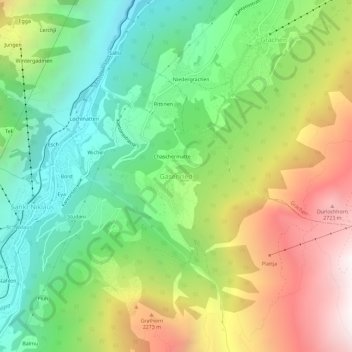
Name: Gasenried topographic map, elevation, terrain.
Location: Gasenried, St. Niklaus, Visp, Wallis, 3924, Schweiz (46.16047 7.80611 46.20047 7.84611)
Average elevation: 5,735 ft
Minimum elevation: 3,173 ft
Maximum elevation: 9,600 ft
Thank you for supporting this site ❤️
Make a donation
Make a donation
Gear up for your next adventure:
As an Amazon Associate, this site earns from qualifying purchases at no extra cost to you.