
Make a donation
Gear up for your next adventure:
As an Amazon Associate, this site earns from qualifying purchases at no extra cost to you.
Boqueron topographic map
Click on the map to display elevation.
Make a donation
Gear up for your next adventure:
As an Amazon Associate, this site earns from qualifying purchases at no extra cost to you.
About this map
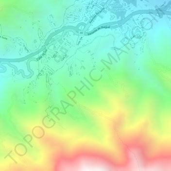
Name: Boqueron topographic map, elevation, terrain.
Location: Boqueron, Ibagué, Centro, Tolima, 730001, Colombia (4.39764 -75.26895 4.41764 -75.24895)
Average elevation: 5,105 ft
Minimum elevation: 4,075 ft
Maximum elevation: 6,877 ft
Make a donation
Gear up for your next adventure:
As an Amazon Associate, this site earns from qualifying purchases at no extra cost to you.
Other topographic maps
Click on a map to view its topography, its elevation and its terrain.
SUELO DE EXPANSION PREDIO LA PISTA SECTOR OESTE 35 HECTAREAS
Average elevation: 3,287 ft
Make a donation
Gear up for your next adventure:
As an Amazon Associate, this site earns from qualifying purchases at no extra cost to you.
Make a donation
Gear up for your next adventure:
As an Amazon Associate, this site earns from qualifying purchases at no extra cost to you.
Make a donation
Gear up for your next adventure:
As an Amazon Associate, this site earns from qualifying purchases at no extra cost to you.