Geolocate

Ponitz topographic map

Click on the map to display elevation.

About this map

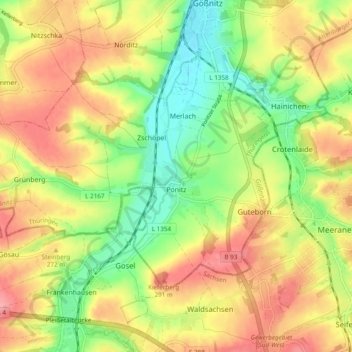
Name: Ponitz topographic map, elevation, terrain.

Location: Ponitz, Gößnitz, Altenburger Land, Thuringia, Germany (50.83947 12.35219 50.87897 12.44844)

Average elevation: 840 ft

Minimum elevation: 676 ft

Maximum elevation: 1,001 ft

Other topographic maps

Click on a map to view its topography, its elevation and its terrain.

Zschernitzsch

Germany > Thuringia > Altenburger Land > Schmölln

Average elevation: 791 ft

Gear up for your next adventure:

🛡️Bear Spray Outdoor - Protection in bear country hikes
🩳Quick‑Dry Hiking Shorts - Comfortable and quick‑dry shorts for summer hiking
🎒Trekking Poles - Sturdy poles for balance and stability on rough terrain
🔌USB Car Charger - Car charger for on‑the‑go power needs
🧢Outdoor Hiking Hat - Sun protection hat for outdoor explorers

As an Amazon Associate, this site earns from qualifying purchases at no extra cost to you.