
Casamicciola topographic map
Interactive map
Click on the map to display elevation.
About this map
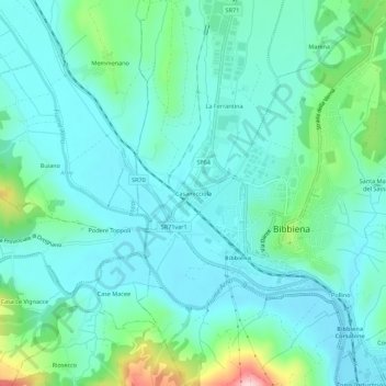
Name: Casamicciola topographic map, elevation, terrain.
Location: Casamicciola, Bibbiena, Arezzo, Toscana, 52011, Italia (43.67921 11.78327 43.71921 11.82327)
Average elevation: 1,191 ft
Minimum elevation: 1,020 ft
Maximum elevation: 1,893 ft
Other topographic maps
Click on a map to view its topography, its elevation and its terrain.
Serravalle
Italia > Toscana > Arezzo > Bibbiena
Serravalle, Bibbiena, Arezzo, Toscana, 52014, Italia
Average elevation: 2,644 ft