
Make a donation
Gear up for your next adventure:
As an Amazon Associate, this site earns from qualifying purchases at no extra cost to you.
Sayre topographic map
Click on the map to display elevation.
Make a donation
Gear up for your next adventure:
As an Amazon Associate, this site earns from qualifying purchases at no extra cost to you.
Sayre
Sayre is located at 35°17′56″N 99°38′12″W / 35.29889°N 99.63667°W / 35.29889; -99.63667 (35.298940, -99.636556). It is located on the North Fork of the Red River, at an elevation of 1,800 feet (550 m) and 128 miles (206 km) west of Oklahoma City. The area is dominated by low rolling red clay hills.
Make a donation
Gear up for your next adventure:
As an Amazon Associate, this site earns from qualifying purchases at no extra cost to you.
About this map
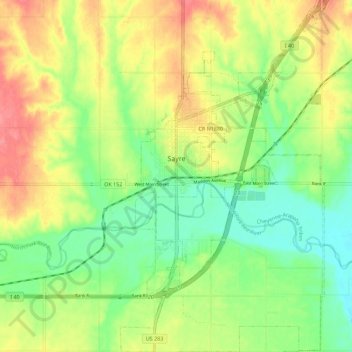
Name: Sayre topographic map, elevation, terrain.
Location: Sayre, Beckham County, Oklahoma, 73662, United States (35.24766 -99.65779 35.33907 -99.59298)
Average elevation: 1,860 ft
Minimum elevation: 1,759 ft
Maximum elevation: 1,985 ft
Beckham County trails, hiking, mountain biking, running and outdoor activities
Make a donation
Gear up for your next adventure:
As an Amazon Associate, this site earns from qualifying purchases at no extra cost to you.
Other topographic maps
Click on a map to view its topography, its elevation and its terrain.
Sayre
United States > Oklahoma > Beckham County > Sayre > Sayre
Sayre is located at 35°17′56″N 99°38′12″W / 35.29889°N 99.63667°W / 35.29889; -99.63667 (35.298940, -99.636556). It is located on the North Fork of the Red River, at an elevation of 1,800 feet (550 m) and 128 miles (206 km) west of Oklahoma City. The area is dominated by low rolling red clay hills.
Average elevation: 1,837 ft