
Make a donation
Gear up for your next adventure:
As an Amazon Associate, this site earns from qualifying purchases at no extra cost to you.
Burkhan Khaldun topographic map
Click on the map to display elevation.
Make a donation
Gear up for your next adventure:
As an Amazon Associate, this site earns from qualifying purchases at no extra cost to you.
Burkhan Khaldun
Burkhan Khaldun means the "God Mountain" and is also called Khentii Khan (The King of the Khentii Mountain range). It is one of the Khentii Mountains in the Khentii Province of northeastern Mongolia. It is the highest mountain of the region, rising to an elevation of 2,362 metres (7,749 ft), and is crescent-shaped. It is the source of several rivers: the Onon and Kherlen rivers flow into the Amur, which has its outfall in the Pacific Ocean; and the rivers Tuul, Kharaa and Yeruu flow northwards to join the Selenge, which empties into the Arctic Ocean. It is in a complex ecosystem with unique biodiversity which is defined as a "transition zone from Siberian permafrost land forms to great steppe".
Make a donation
Gear up for your next adventure:
As an Amazon Associate, this site earns from qualifying purchases at no extra cost to you.
About this map
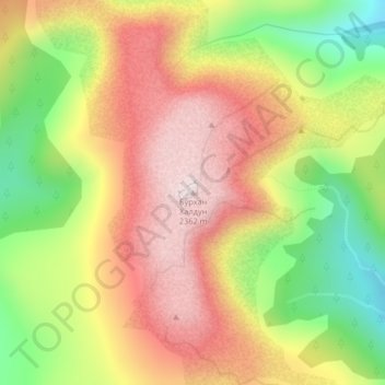
Name: Burkhan Khaldun topographic map, elevation, terrain.
Location: Burkhan Khaldun, Omnodelger, Khentii, Mongolia (48.76197 109.01078 48.76207 109.01088)
Average elevation: 6,932 ft
Minimum elevation: 5,991 ft
Maximum elevation: 7,746 ft
Make a donation
Gear up for your next adventure:
As an Amazon Associate, this site earns from qualifying purchases at no extra cost to you.