
Make a donation
Gear up for your next adventure:
As an Amazon Associate, this site earns from qualifying purchases at no extra cost to you.
Wilson Creek topographic map
Click on the map to display elevation.
Make a donation
Gear up for your next adventure:
As an Amazon Associate, this site earns from qualifying purchases at no extra cost to you.
About this map
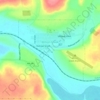
Name: Wilson Creek topographic map, elevation, terrain.
Location: Wilson Creek, Grant County, Washington, United States (47.41278 -119.13347 47.42920 -119.10688)
Average elevation: 1,362 ft
Minimum elevation: 1,250 ft
Maximum elevation: 1,549 ft
Grant County trails, hiking, mountain biking, running and outdoor activities
Make a donation
Gear up for your next adventure:
As an Amazon Associate, this site earns from qualifying purchases at no extra cost to you.
Other topographic maps
Click on a map to view its topography, its elevation and its terrain.
Make a donation
Gear up for your next adventure:
As an Amazon Associate, this site earns from qualifying purchases at no extra cost to you.
Moses Lake
United States > Washington > Grant County > Moses Lake > Moses Lake
Average elevation: 1,122 ft