Geolocate

Schwana topographic map

Click on the map to display elevation.

About this map

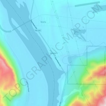
Name: Schwana topographic map, elevation, terrain.

Location: Schwana, Grant County, Washington, 99321, United States (46.80265 -119.94658 46.84265 -119.90658)

Average elevation: 705 ft

Minimum elevation: 482 ft

Maximum elevation: 2,123 ft

Grant County trails, hiking, mountain biking, running and outdoor activities

Other topographic maps

Click on a map to view its topography, its elevation and its terrain.

Grand Coulee

United States > Washington > Grant County

Average elevation: 1,647 ft

Desert Aire

United States > Washington > Grant County

Desert Aire is a census-designated place (CDP) in Grant County, Washington, United States. Desert Aire's elevation is 560 ft (170 m). The population was 1,626 at the 2010 census, up from 1,124 at the 2000 census.

Average elevation: 581 ft

Wilson Creek

United States > Washington > Grant County

Average elevation: 1,362 ft

Marlin

United States > Washington > Grant County

Average elevation: 1,411 ft

Hartline

United States > Washington > Grant County

Average elevation: 1,923 ft

Mattawa

United States > Washington > Grant County

Average elevation: 732 ft

Carpenter Park

United States > Washington > Grant County > Moses Lake

Average elevation: 1,060 ft

Gear up for your next adventure:

🎒Hydration Pack - Hands‑free water reservoir for long hikes
Backpacking Tent - Lightweight and durable tent for multi‑day hikes
🧦Merino Wool Socks - Moisture-wicking, blister-preventing socks for long treks
💧Water Filtration Bottles - Safely drink from streams and lakes while exploring
🪶Survival Guide Book - Expert advice for emergency preparedness

As an Amazon Associate, this site earns from qualifying purchases at no extra cost to you.