Geolocate

Hilt topographic map

Click on the map to display elevation.

About this map

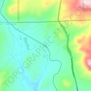
Name: Hilt topographic map, elevation, terrain.

Location: Hilt, Siskiyou County, CAL Fire Northern Region, California, United States (41.97486 -122.64336 42.01486 -122.60336)

Average elevation: 3,136 ft

Minimum elevation: 2,700 ft

Maximum elevation: 4,121 ft

Siskiyou County trails, hiking, mountain biking, running and outdoor activities

Other topographic maps

Click on a map to view its topography, its elevation and its terrain.

McCloud

United States > California > Siskiyou County

McCloud is located at 41°15′17″N 122°8′11″W / 41.25472°N 122.13639°W / 41.25472; -122.13639 (41.254682, -122.136321) on the southern slope of Mount Shasta, at an elevation of 3,271 feet (997 m) above sea level.

Average elevation: 3,314 ft

Montague

United States > California > Siskiyou County

Average elevation: 2,582 ft

Dorris

United States > California > Siskiyou County

Average elevation: 4,278 ft

Crater Lake

United States > California > Siskiyou County

Average elevation: 7,431 ft

Etna

United States > California > Siskiyou County

Average elevation: 3,015 ft

Hornbrook

United States > California > Siskiyou County

Average elevation: 2,310 ft

Gazelle

United States > California > Siskiyou County

Average elevation: 2,825 ft

Gear up for your next adventure:

😴Insulated Sleeping Pads - Compact and warm pads for high-elevation camping
🌧️Backpack Rain Cover - Keep gear dry in wet weather
📚Navigation Handbooks - Master the art of reading topographic maps and using a compass
🥄Camping Utensil Set - Lightweight utensils for outdoor meals
🛏️Cold Weather Sleeping Bag - Warm sleeping bag for cold conditions

As an Amazon Associate, this site earns from qualifying purchases at no extra cost to you.