Geolocate

Coyle topographic map

Click on the map to display elevation.

About this map

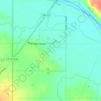
Name: Coyle topographic map, elevation, terrain.

Location: Coyle, Logan County, Oklahoma, United States (35.94923 -97.24759 35.96029 -97.22920)

Average elevation: 896 ft

Minimum elevation: 846 ft

Maximum elevation: 1,014 ft

Logan County trails, hiking, mountain biking, running and outdoor activities

Other topographic maps

Click on a map to view its topography, its elevation and its terrain.

Iconium

United States > Oklahoma > Logan County

Average elevation: 1,073 ft

Gear up for your next adventure:

📦Gear Storage Bags - Organize and protect outdoor equipment
🎒Hydration Pack - Hands‑free water reservoir for long hikes
Backpacking Tent - Lightweight and durable tent for multi‑day hikes
🏕️Tent Footprint - Protect your tent base from wear
Solar GPS Watches - Advanced multisport watches with built-in topographic maps

As an Amazon Associate, this site earns from qualifying purchases at no extra cost to you.