Geolocate
👉 Easily get elevation data in JSON, GeoTIFF and KML formats using Elevation API
Thank you for supporting this site ❤️
Make a donation

Iconium topographic map

Click on the map to display elevation.

About this map

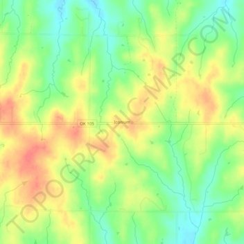
Name: Iconium topographic map, elevation, terrain.

Location: Iconium, Logan County, Oklahoma, United States (35.84922 -97.20781 35.88922 -97.16781)

Average elevation: 1,073 ft

Minimum elevation: 978 ft

Maximum elevation: 1,165 ft

Logan County trails, hiking, mountain biking, running and outdoor activities

Other topographic maps

Click on a map to view its topography, its elevation and its terrain.

Langston

United States > Oklahoma > Logan County

Average elevation: 968 ft

Meridian

United States > Oklahoma > Logan County

Average elevation: 1,017 ft

Coyle

United States > Oklahoma > Logan County

Average elevation: 896 ft

Gear up for your next adventure:

🪵Folding Camp Saw - Compact saw for wood and campsite work
📱Heavy-Duty Phone Cases - Drop-proof and waterproof protection for outdoor navigation
🧤Hiking Gloves - Protective gloves for rugged trails
GPS Sports Watch - GPS watch for running, hiking and training
📻Weather Alert Radios - Stay informed of storm risks while off-the-grid

As an Amazon Associate, this site earns from qualifying purchases at no extra cost to you.