
Thank you for supporting this site ❤️
Make a donation
Make a donation
Gear up for your next adventure:
As an Amazon Associate, this site earns from qualifying purchases at no extra cost to you.
Tornede topographic map
Click on the map to display elevation.
Thank you for supporting this site ❤️
Make a donation
Make a donation
Gear up for your next adventure:
As an Amazon Associate, this site earns from qualifying purchases at no extra cost to you.
About this map
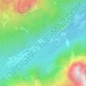
Name: Tornede topographic map, elevation, terrain.
Location: Tornede, Auronzo di Cadore, Belluno, Veneto, 32041, Italia (46.52220 12.29136 46.56220 12.33136)
Average elevation: 4,813 ft
Minimum elevation: 3,261 ft
Maximum elevation: 8,642 ft
Thank you for supporting this site ❤️
Make a donation
Make a donation
Gear up for your next adventure:
As an Amazon Associate, this site earns from qualifying purchases at no extra cost to you.