
Make a donation
Gear up for your next adventure:
As an Amazon Associate, this site earns from qualifying purchases at no extra cost to you.
Bernshausen topographic map
Click on the map to display elevation.
Make a donation
Gear up for your next adventure:
As an Amazon Associate, this site earns from qualifying purchases at no extra cost to you.
Bernshausen
Bernshausen liegt östlich vom Hauptkamm des Rothaargebirges im Wittgensteiner Land etwa 21 km östlich von Siegen, 18 km nördlich von Dillenburg, 7 km südwestlich von Bad Laasphe und 3 km (jeweils Luftlinie) südwestlich von dessen Ortsteil Banfe. Im Naturpark Sauerland-Rothaargebirge auf Höhen zwischen 420 und 460 m ü. NHN gelegen wird es südlich vom Banfe-Zufluss Bernshäuser Bach (Bernshäuser Wasser) passiert. Nach Südwesten steigt die Landschaft zum 694,1 m hohen Kompass an, dem höchsten Berg im Bad Laaspher Stadtgebiet. In der Umgebung entspringen nahe beieinander die Flüsse Eder, Lahn und Sieg, wobei die Lahn im quellnahen Oberlaufbereich von der im nördlichen Nachbartal der Ortschaft fließenden Ilse gespeist wird.
Make a donation
Gear up for your next adventure:
As an Amazon Associate, this site earns from qualifying purchases at no extra cost to you.
About this map
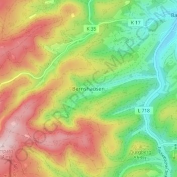
Name: Bernshausen topographic map, elevation, terrain.
Average elevation: 1,703 ft
Minimum elevation: 1,217 ft
Maximum elevation: 2,293 ft
Make a donation
Gear up for your next adventure:
As an Amazon Associate, this site earns from qualifying purchases at no extra cost to you.
Other topographic maps
Click on a map to view its topography, its elevation and its terrain.
57334
Deutschland > Nordrhein-Westfalen > Kreis Siegen-Wittgenstein > Bad Laasphe > Banfe
Average elevation: 1,640 ft
Schloß Wittgenstein
Deutschland > Nordrhein-Westfalen > Kreis Siegen-Wittgenstein > Bad Laasphe > Laaspherhütte
Average elevation: 1,309 ft