Geolocate

Carney topographic map

Click on the map to display elevation.

About this map

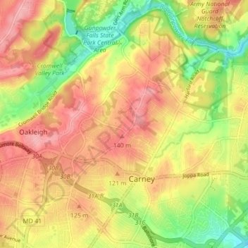
Name: Carney topographic map, elevation, terrain.

Location: Carney, Oakleigh, Baltimore County, Maryland, United States (39.38046 -76.56840 39.43171 -76.49907)

Average elevation: 338 ft

Minimum elevation: 125 ft

Maximum elevation: 505 ft

Baltimore County trails, hiking, mountain biking, running and outdoor activities

Gear up for your next adventure:

🧼Biodegradable Camping Soap - Eco‑friendly soap for outdoor hygiene
🧭Outdoor Navigation Book - Learn advanced navigation skills
🛡️Insect Repellent - Protection against bugs during outdoor activities
🔭Stargazing Telescopes - Perfect for camping in low-light pollution areas shown on maps
🔥Fast-Boil Camping Stoves - Efficient cooking systems for quick trail meals

As an Amazon Associate, this site earns from qualifying purchases at no extra cost to you.