
Make a donation
Gear up for your next adventure:
As an Amazon Associate, this site earns from qualifying purchases at no extra cost to you.
Hochwald topographic map
Click on the map to display elevation.
Make a donation
Gear up for your next adventure:
As an Amazon Associate, this site earns from qualifying purchases at no extra cost to you.
About this map
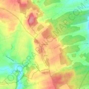
Name: Hochwald topographic map, elevation, terrain.
Average elevation: 2,257 ft
Minimum elevation: 2,060 ft
Maximum elevation: 2,438 ft
Make a donation
Gear up for your next adventure:
As an Amazon Associate, this site earns from qualifying purchases at no extra cost to you.
Other topographic maps
Click on a map to view its topography, its elevation and its terrain.
Feckenhausen
Deutschland > Baden-Württemberg > Landkreis Rottweil > Rottweil
Average elevation: 2,185 ft
Hausen
Deutschland > Baden-Württemberg > Landkreis Rottweil > Rottweil
In Rottweil steht der 246 Meter hohe TK-Elevator-Testturm, der weltweit zweithöchste Testturm für Aufzugsanlagen. Die Konstruktion dient dem Test und der Zertifizierung von Hochgeschwindigkeitsaufzügen. Die öffentliche Besucherplattform auf 232 Meter Höhe ist die höchste Besucherplattform Deutschlands.…
Average elevation: 2,169 ft