
Make a donation
Gear up for your next adventure:
As an Amazon Associate, this site earns from qualifying purchases at no extra cost to you.
Sella della Turra topographic map
Click on the map to display elevation.
Make a donation
Gear up for your next adventure:
As an Amazon Associate, this site earns from qualifying purchases at no extra cost to you.
About this map
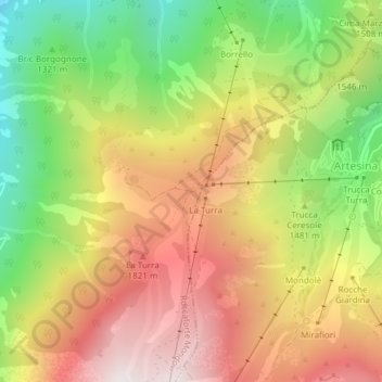
Name: Sella della Turra topographic map, elevation, terrain.
Location: Sella della Turra, Roccaforte Mondovì, Cuneo, Piemonte, Italia (44.24563 7.73930 44.24573 7.73940)
Average elevation: 5,016 ft
Minimum elevation: 3,153 ft
Maximum elevation: 6,778 ft
Make a donation
Gear up for your next adventure:
As an Amazon Associate, this site earns from qualifying purchases at no extra cost to you.
Other topographic maps
Click on a map to view its topography, its elevation and its terrain.
Rifugio Mondovì - Havis De Giorgio
Italia > Piemonte > Cuneo > Roccaforte Mondovì
Il rifugio Havis De Giorgio - Mondovì (a volte indicato semplicemente come rifugio Mondovì) è un rifugio situato nella catena delle Alpi Liguri nel comune di Roccaforte Mondovì, in provincia di Cuneo, a 1761 metri di altitudine.
Average elevation: 6,407 ft