Geolocate

Vass topographic map

Click on the map to display elevation.

About this map

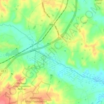
Name: Vass topographic map, elevation, terrain.

Location: Vass, Moore County, North Carolina, United States (35.20933 -79.33138 35.27069 -79.26408)

Average elevation: 299 ft

Minimum elevation: 213 ft

Maximum elevation: 433 ft

Moore County trails, hiking, mountain biking, running and outdoor activities

Other topographic maps

Click on a map to view its topography, its elevation and its terrain.

Lobelia

United States > North Carolina > Moore County

Average elevation: 236 ft

Spies

United States > North Carolina > Moore County

Average elevation: 482 ft

Sandhill

United States > North Carolina > Moore County > Foxfire

Average elevation: 456 ft

Gear up for your next adventure:

🔭Telescopic Hiking Pole - Adjustable pole for hiking stability
📱Solar Portable Charger - Solar power bank for charging devices off‑grid
🔊Portable Camp Speaker - Music and alerts at camp
🪄Magnetic Compass - Accurate compass for navigation
🚗GPS Dash Cams - Record your scenic drives through mountain passes and canyons

As an Amazon Associate, this site earns from qualifying purchases at no extra cost to you.