Geolocate

Yorkshire topographic map

Click on the map to display elevation.

About this map

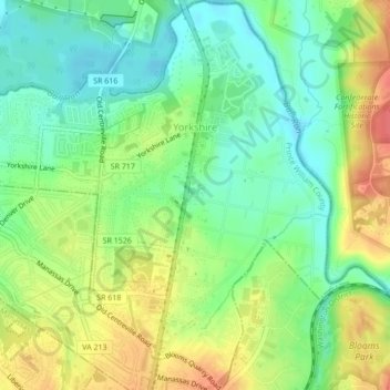
Name: Yorkshire topographic map, elevation, terrain.

Location: Yorkshire, Prince William County, Virginia, 20111, United States (38.77054 -77.47328 38.80395 -77.43274)

Average elevation: 220 ft

Minimum elevation: 135 ft

Maximum elevation: 341 ft

Other topographic maps

Click on a map to view its topography, its elevation and its terrain.

Antioch

United States > Virginia > Prince William County

Average elevation: 653 ft

Bristow

United States > Virginia > Prince William County

Average elevation: 220 ft

Bull Run

United States > Virginia > Prince William County

Average elevation: 253 ft

Bristow

United States > Virginia > Prince William County

Average elevation: 220 ft

Gear up for your next adventure:

🌐World Map Poster - Decorative world maps with topographic info
🧺Microfiber Travel Towels - Compact and fast-drying towels for trail use
🚑Emergency Bivvies - Heat-reflective sleeping bags for survival situations
⛑️Personal Locator Beacon - Safety beacon for emergencies
🦟Ultrasonic Repellers - Create a bug-free zone at your camp or rest stop

As an Amazon Associate, this site earns from qualifying purchases at no extra cost to you.