
Thank you for supporting this site ❤️
Make a donation
Make a donation
Gear up for your next adventure:
As an Amazon Associate, this site earns from qualifying purchases at no extra cost to you.
Uttarsu topographic map
Click on the map to display elevation.
Thank you for supporting this site ❤️
Make a donation
Make a donation
Gear up for your next adventure:
As an Amazon Associate, this site earns from qualifying purchases at no extra cost to you.
About this map
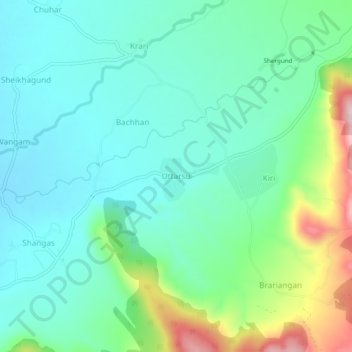
Name: Uttarsu topographic map, elevation, terrain.
Location: Uttarsu, Shangus tehsil, Anantnag, Jammu and Kashmir, India (33.68776 75.28214 33.72776 75.32214)
Average elevation: 5,843 ft
Minimum elevation: 5,584 ft
Maximum elevation: 6,608 ft
Thank you for supporting this site ❤️
Make a donation
Make a donation
Gear up for your next adventure:
As an Amazon Associate, this site earns from qualifying purchases at no extra cost to you.