
Make a donation
Gear up for your next adventure:
As an Amazon Associate, this site earns from qualifying purchases at no extra cost to you.
Bulu Hatu topographic map
Click on the map to display elevation.
Make a donation
Gear up for your next adventure:
As an Amazon Associate, this site earns from qualifying purchases at no extra cost to you.
About this map
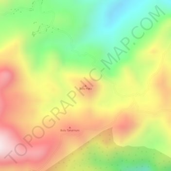
Name: Bulu Hatu topographic map, elevation, terrain.
Location: Bulu Hatu, South Sulawesi, Sulawesi, Indonesia (-5.05515 120.06495 -5.05505 120.06505)
Average elevation: 2,113 ft
Minimum elevation: 1,145 ft
Maximum elevation: 3,009 ft
Make a donation
Gear up for your next adventure:
As an Amazon Associate, this site earns from qualifying purchases at no extra cost to you.
Other topographic maps
Click on a map to view its topography, its elevation and its terrain.
Makassar
Makassar City is a city located near the coast that stretches along the western and northern corridors and is also known as the "Waterfront City" which contains several rivers such as the Tallo River, Jeneberang River, and Pampang River) all of which flow into the city. Makassar City is a stretch of lowland at…
Average elevation: 43 ft