
Thebes topographic map
Interactive map
Click on the map to display elevation.
About this map
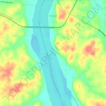
Name: Thebes topographic map, elevation, terrain.
Location: Thebes, Alexander County, Illinois, 62990, United States (37.18685 -89.46763 37.22681 -89.44077)
Average elevation: 390 ft
Minimum elevation: 305 ft
Maximum elevation: 499 ft
Other topographic maps
Click on a map to view its topography, its elevation and its terrain.
Cairo
United States > Illinois > Alexander County
Cairo, Alexander County, Illinois, 62914, United States
Average elevation: 312 ft
Cairo
United States > Illinois > Alexander County > Cairo > Cairo
Cairo, Alexander County, Illinois, 62914, United States
Average elevation: 312 ft
Dogtooth Bend Mounds
United States > Illinois > Alexander County
Dogtooth Bend Mounds, Alexander County, Illinois, 62962, United States
Average elevation: 322 ft
McClure
United States > Illinois > Alexander County
McClure, Alexander County, Illinois, United States
Average elevation: 338 ft
Big Cypress
United States > Illinois > Alexander County
Big Cypress, Alexander County, Illinois, 62969, United States
Average elevation: 331 ft