
Make a donation
Gear up for your next adventure:
As an Amazon Associate, this site earns from qualifying purchases at no extra cost to you.
Donvale topographic map
Click on the map to display elevation.
Make a donation
Gear up for your next adventure:
As an Amazon Associate, this site earns from qualifying purchases at no extra cost to you.
About this map
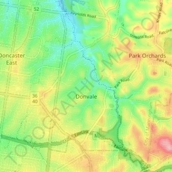
Name: Donvale topographic map, elevation, terrain.
Average elevation: 354 ft
Minimum elevation: 151 ft
Maximum elevation: 633 ft
Make a donation
Gear up for your next adventure:
As an Amazon Associate, this site earns from qualifying purchases at no extra cost to you.
Other topographic maps
Click on a map to view its topography, its elevation and its terrain.
Dandenong Ranges
Australia > Victoria > Melbourne
The topography consists of a series of ridges dissected by deeply cut streams. Sheltered gullies in the south of the range are home to temperate rain forest, fern gullies and Mountain Ash forest Eucalyptus regnans, whereas the drier ridges and exposed northern slopes are covered by dry sclerophyll forest of…
Average elevation: 1,496 ft