
Make a donation
Gear up for your next adventure:
As an Amazon Associate, this site earns from qualifying purchases at no extra cost to you.
Mbabane topographic map
Click on the map to display elevation.
Make a donation
Gear up for your next adventure:
As an Amazon Associate, this site earns from qualifying purchases at no extra cost to you.
Mbabane
It has an estimated population of 94,874 (2010). It is located on the Mbabane River and its tributary the Polinjane River in the Mdzimba Mountains. It is located in the Hhohho Region, of which it is also the capital. The average elevation of the city is 1,243 meters. It lies on the MR3 road.
Make a donation
Gear up for your next adventure:
As an Amazon Associate, this site earns from qualifying purchases at no extra cost to you.
About this map
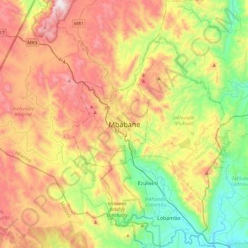
Name: Mbabane topographic map, elevation, terrain.
Location: Mbabane, Inkhundla Mbabane, Hhohho Region, H100, Eswatini (-26.48575 30.98466 -26.16575 31.30466)
Average elevation: 3,734 ft
Minimum elevation: 2,018 ft
Maximum elevation: 5,991 ft
Make a donation
Gear up for your next adventure:
As an Amazon Associate, this site earns from qualifying purchases at no extra cost to you.