
Thank you for supporting this site ❤️
Make a donation
Make a donation
Gear up for your next adventure:
As an Amazon Associate, this site earns from qualifying purchases at no extra cost to you.
Güttersbach topographic map
Click on the map to display elevation.
Thank you for supporting this site ❤️
Make a donation
Make a donation
Gear up for your next adventure:
As an Amazon Associate, this site earns from qualifying purchases at no extra cost to you.
About this map
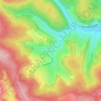
Name: Güttersbach topographic map, elevation, terrain.
Location: Güttersbach, Mossautal, Odenwaldkreis, Hessen, Deutschland (49.59947 8.87563 49.63064 8.92307)
Average elevation: 1,260 ft
Minimum elevation: 919 ft
Maximum elevation: 1,568 ft
Thank you for supporting this site ❤️
Make a donation
Make a donation
Gear up for your next adventure:
As an Amazon Associate, this site earns from qualifying purchases at no extra cost to you.