Geolocate

Lazbuddie topographic map

Click on the map to display elevation.

About this map

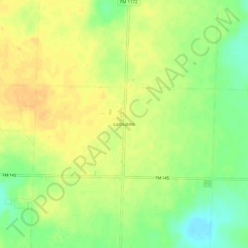
Name: Lazbuddie topographic map, elevation, terrain.

Location: Lazbuddie, Parmer County, Texas, 79053, United States (34.37313 -102.63132 34.41313 -102.59132)

Average elevation: 3,947 ft

Minimum elevation: 3,885 ft

Maximum elevation: 3,983 ft

Parmer County trails, hiking, mountain biking, running and outdoor activities

Other topographic maps

Click on a map to view its topography, its elevation and its terrain.

Friona

United States > Texas > Parmer County

Average elevation: 4,029 ft

Gear up for your next adventure:

🧯Portable Fire Pit - Compact fire pit for camping spots
🪶Thermal Camp Blanket - Extra warmth for cold nights
📷Action Camera - Capture your outdoor adventures in HD
🔋Solar Power Banks - Keep your GPS and phone charged in remote wilderness areas
🧭Hiking Compass - Precision compass for reliable navigation in the wilderness

As an Amazon Associate, this site earns from qualifying purchases at no extra cost to you.