
Corton topographic map
Click on the map to display elevation.
About this map
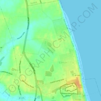
Name: Corton topographic map, elevation, terrain.
Location: Corton, East Suffolk, Suffolk, England, United Kingdom (52.50435 1.72205 52.53210 1.75838)
Average elevation: 36 ft
Minimum elevation: -7 ft
Maximum elevation: 98 ft
Other topographic maps
Click on a map to view its topography, its elevation and its terrain.
Falkenham Marshes
United Kingdom > England > Suffolk > East Suffolk > Falkenham
Average elevation: 0 ft
Felixstowe Marshes
United Kingdom > England > Suffolk > East Suffolk > Felixstowe
Average elevation: 3 ft