
Make a donation
Gear up for your next adventure:
As an Amazon Associate, this site earns from qualifying purchases at no extra cost to you.
Westwood topographic map
Click on the map to display elevation.
Make a donation
Gear up for your next adventure:
As an Amazon Associate, this site earns from qualifying purchases at no extra cost to you.
Westwood
Westwood is a census-designated place in Boyd County, Kentucky, United States. The population was 4,387 at the 2020 census. A suburb of Ashland, the two areas are closely affiliated, sharing a ZIP code and bus system. Westwood is located on a flat to hilly elevation just west of the Ohio River. The flat hilltop is unusual to eastern Kentucky and was created by the preglacial Teays River which existed in ancient times and flowed in the opposite direction of the Ohio River. Westwood is part of the Huntington–Ashland metropolitan area.
Make a donation
Gear up for your next adventure:
As an Amazon Associate, this site earns from qualifying purchases at no extra cost to you.
About this map
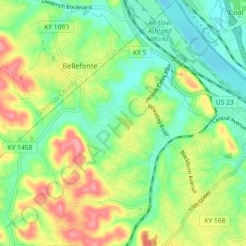
Name: Westwood topographic map, elevation, terrain.
Location: Westwood, Fairview, Boyd County, Kentucky, United States (38.45635 -82.70721 38.50581 -82.65651)
Average elevation: 630 ft
Minimum elevation: 505 ft
Maximum elevation: 827 ft
Boyd County trails, hiking, mountain biking, running and outdoor activities
Make a donation
Gear up for your next adventure:
As an Amazon Associate, this site earns from qualifying purchases at no extra cost to you.