
Make a donation
Gear up for your next adventure:
As an Amazon Associate, this site earns from qualifying purchases at no extra cost to you.
Totham Hill topographic map
Click on the map to display elevation.
Make a donation
Gear up for your next adventure:
As an Amazon Associate, this site earns from qualifying purchases at no extra cost to you.
About this map
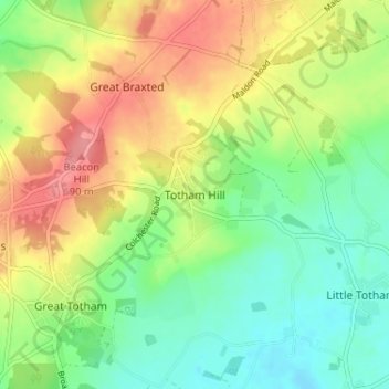
Name: Totham Hill topographic map, elevation, terrain.
Location: Totham Hill, Maldon, Essex, England, CM9 8DS, United Kingdom (51.76386 0.69100 51.80386 0.73100)
Average elevation: 157 ft
Minimum elevation: 43 ft
Maximum elevation: 305 ft
Make a donation
Gear up for your next adventure:
As an Amazon Associate, this site earns from qualifying purchases at no extra cost to you.
Other topographic maps
Click on a map to view its topography, its elevation and its terrain.
Make a donation
Gear up for your next adventure:
As an Amazon Associate, this site earns from qualifying purchases at no extra cost to you.
Make a donation
Gear up for your next adventure:
As an Amazon Associate, this site earns from qualifying purchases at no extra cost to you.
Woodham Mortimer
United Kingdom > England > Essex > Maldon > Woodham Mortimer
Average elevation: 144 ft
Tolleshunt Major
United Kingdom > England > Essex > Maldon > Tolleshunt Major
Average elevation: 69 ft
Make a donation
Gear up for your next adventure:
As an Amazon Associate, this site earns from qualifying purchases at no extra cost to you.