Geolocate

Shelby topographic map

Click on the map to display elevation.

About this map

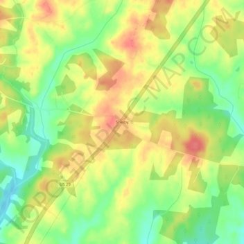
Name: Shelby topographic map, elevation, terrain.

Location: Shelby, Madison County, Virginia, 22738, United States (38.30124 -78.32806 38.34124 -78.28806)

Average elevation: 591 ft

Minimum elevation: 476 ft

Maximum elevation: 692 ft

Madison County trails, hiking, mountain biking, running and outdoor activities

Other topographic maps

Click on a map to view its topography, its elevation and its terrain.

Blakey Ridge

United States > Virginia > Madison County

Average elevation: 1,362 ft

Gear up for your next adventure:

🪶Wildlife Field Guides - Learn animal tracking and species ID
Backpacking Tent - Lightweight and durable tent for multi‑day hikes
📚Navigation Handbooks - Master the art of reading topographic maps and using a compass
🧣Hiking Neck Gaiter - Multi‑use neck protection for outdoor weather
💧Water Purification System - Clean water on the trail with reliable purifiers

As an Amazon Associate, this site earns from qualifying purchases at no extra cost to you.